Test Message TEST MESSAGE - Carroll Co.

img img img
Radar Legend
Bless America
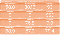
Early Morning OBSERVATIONS: Its early morning,clear night and it feels cool outside. The temperature has been falling for the last few hours. There is a calm from the west north west. Visibility is about 10 mile(s). The barometer has been steady over the last hour. So far no measurable precipitation has been observed today.
transparent spacer
METRIC | IMPERIAL
Updated: 02-May-2024 @ 4:27am   (0 sec ago)
Temperature Current Conditions Forecast / Storm Prediction
Currently Outside: Colder 1.1°F than last hour.

58.4°F

Cool
High Today
64.1°F
00:00
Low Today
58.4°F
04:21
Yest High
86.3°F
17:38
Yest Low
61.2°F
06:39
Station High
91.0°F
2018*
Station Low
39.0°F
2005*
BWI High
90°F
2018
BWI Low
36°F
1978
* This Station's Records Since 8/2004
Clear Night Clear Night

Calm Wind:  WNW
0.0

Gusting to:
0.0 mph
Current Rain Rain:
0.00 in
Fire Weather Index: MINIMAL Current FWI:4
Fire Danger:
7.5 of 232
Overnight

Overnight: Mostly Clear
Mostly Clear
Thursday

Thursday: Sunny
Sunny
Thursday
Night
Thursday Night: Mostly Clear
Mostly Clear
Lo 60°F Hi 91°F Lo 62°F
SPC Activity Map
Dew Point Liquid Precipitation Wind Speed Sun/Moon
Current: Decreased 0.8°F since last hour. 55.2°F
Last Hour: Decreased 0.8°F since last hour. -0.8°F
High00:05: 57.7°F
Low04:21: 54.9°F
Record High: 87.6°F on
16-Aug-2017
Record Low: -34.2°F on
17-Nov-2005
Wetbulb: 56.6°F
Today: 0.00 in
Yesterday: 0.03 in
Last 7 Days: 0.16 in
May Rain: 0.02 in
May to Date
  Avg:10
0.00 in
May to Date
  Diff from Avg:10
Over 0.02 in for the month 0.02 in
May Avg: 3.81 in
Diff from Avg: Under 3.79 in for the month 3.79 in
Season:1 15.08 in
YTD
  Avg:11
11.21 in
YTD
  Diff from Avg:11
Over 3.87 in for the year 3.87 in
Last Rain
Time/Date:
1-May-2024
at 00:12
46 rain days in 2024
1 day in May
0 days since last rain
Current: WNW  0.0 mph
1Hr Average: Calm
Wind Run: 0.00 miles
Wind Gust
Current: 0.0 mph
Today: 0.0 mph 15:21
Month: 16.1 mph 1-May
Year: 64.4 mph 5-Mar
Record Gust: 92.0 mph
19-Sep-2003
Sunlight:
13 h 55 m 56 s
of Sunlight Yesterday
13 h 58 m 7 s
of Sunlight Today
Which is
2 min 11 sec longer than
yesterday
14 h 0 m 16 s
of Sunlight Tomorrow
(Noon) graph (Midnight)

Waning Crescent
Waning Crescent, 23 days, 14 hours, 8 minutes in cycle
40%
Illuminated
Humidity Barometer
Current: Increased 1% since last hour. 89%
Last Hour: Increased 1% since last hour. 1%
High04:25: 89%
Low00:00: 79%
Record High: 100%
29-Sep-2005
Record Low: 0%
17-Aug-2023
Current: Rising 0.1  inHg/hr 1012.9 inHg
Last Hour: Steady
High00:51: 1013.1
Low02:52: 1012.6
Record High: 1045.5 inHg
28-Feb-2015
Record Low: 963.4 inHg
29-Oct-2012
Heating Degree Days Lightning Strikes Wind Chill Air
Today: 0.4
May: 0.4
2024 to Date: 2266.8
Cooling Degree Days
2024 to Date: 46.2
Last Min: 0
Last 5 Mins: 0
Last 30 Mins: 0
Last 60 Mins: 0
Last 12 Hrs: 6
May: 29
2024 to Date: 2341
Last
Strike:
20:39:38
05-Jan-2024
Current: 58.4°F
Low04:21: 58.4°F
Yesterday: 61.2°F
Record: -25.1°F
21-Jan-2019
Error - Data Not
Available For
Baltimore Metro


Data Not Available

Davis AirLink Sensor13

Quality Index:
40.0
    Good Air Quality    
Particulate Matter Concentration µg/m3
PM1.0: 8.3   PM2.5: 9.6   PM10: 10.0
UV Summary/Forecast Solar Summary
High Yest:   5.9 @ 12:48
May-02

8.1
May-03

8.0
May-04

7.8
High Yest:   1167.0 @ 11:53
Sun Hours Today:
00:00
   This Month: 08:31 Hrs
Rise: 06:06  Set: 20:00
Almanac Irrigation Index5 Station All Time Records Cloud Level
Currently: Early Morning
YTD Avg Temp: 46.8°F
Sunrise: 06:06
Sunset: 20:00
Moonrise: 03:13
Moonset: 13:39
Full Moon: 23-Apr-2024
New Moon: 03:23 UTC
07-May-2024
Updated at Midnight
Current ET: 0.01 in
7-Days Rain: 0.16 in
7-Days ET: 1.14 in
7-Day:  0.982 in water in deficit of what evaporated in last 7 days. 0.982 in
May:  0.22 in water in deficit of what evaporated this month. 0.22 in
HIGHS: LOWS:
104.2°F
22-Jul-2011
-0.0°F
1-Mar-2011
Daytime Records
  102.9°F°F
07-Jul-2012
  0.5°F°F
23-Nov-2019
Nitetime Records
  90.3°F°F
08-Jul-2012
  -0.0°F°F
01-Mar-2018
ICN:1 | S3C2:4 | Ajax 3.xx
ISS:Ok | CON:4.8 | RCP:100%
METRIC | IMPERIAL
Updated: 02-May-2024 @ 4:27am  
1 Rain season: Jan 1st to Dec 31st.   2 Snow season July 1st to June 30th.   3 Snow manually measured and updated as required.   4 Updated at Noon Eastern Standard Time.   5 Estimated amount of water needed to replace the water used by plants and evaporation from the past week. (Negative numbers mean amount of water needed, positive numbers mean excess water is present).   6 Air Quality Index for Metro Balto, MD (9) is provided by AirNow and is updated hourly between the hours of 6AM and Midnight.   10 Historical average only to day 2 of just the month of May for this station since 2005.   11 Historical average rain this season to day 2 of May for this station since 2005.   12 NWS Zone Forecast (MDZ011).   13 Data from Davis AirLink AQ Sensor located at Halethorpe Weather-Watch.  
 NWS Weather Forecast  -   Outlook Overnight & Thursday
Overnight

Overnight: Mostly Clear
Mostly Clear

Lo 60°F
NWS forecast: Mostly clear, with a low around 60. Southwest wind around 3 mph.
Local zone forecast12: Mostly clear. Lows around 60. South winds around 5 mph.
Thursday

Thursday: Sunny
Sunny

Hi 91°F
NWS forecast: Sunny, with a high near 91. West wind 3 to 9 mph.
 NWS Short Term Weather Forecast
Thursday
Night
Thursday Night: Mostly Clear
Mostly Clear
Friday

Friday: Partly Sunny
Partly Sunny
Friday
Night
Friday Night: Mostly Cloudy then Chance Rain Showers
Mostly Cloudy then Chance Rain Showers
Saturday

Saturday: Chance Rain Showers
Chance Rain Showers
Saturday
Night
Saturday Night: Rain Showers Likely
Rain Showers Likely
Sunday

Sunday: Showers And Thunderstorms Likely
Showers And T-Storms Likely
Sunday
Night
Sunday Night: Showers And Thunderstorms Likely
Showers And T-Storms Likely
Lo 62°F Hi 79°F Lo 53°F Hi 63°F Lo 54°F Hi 70°F Lo 60°F
ajax-dashboard6.php - Version 6.95h - 20-Feb-2023 - Script by: Scott of BurnsvilleWeatherLIVE.com
Now supported by Saratoga-weather.org Download